AI leverages satellite imagery to enrich digital maps
By tapping into the global road network visible across millions of satellite images, and having learned how to extract relevant road features from known datasets, the RoadTagger model is able to enrich poorly tagged digital maps even for parts of the world overlooked by large digital mapping companies.
Indeed, creating detailed maps is an expensive and time-consuming process: Think of the Google car driving around with cameras, combining the collected video data with other data to create up-to-date maps. This is what may enable a GPS system to make the difference between diverging or merging lanes, helping the driver take the right direction. Similarly, incorporating information about parking spots can help drivers plan ahead, while mapping bicycle lanes can help cyclists negotiate busy city streets. Providing updated information on road conditions can also improve planning for disaster relief.
Now, analyzing satellite imagery, RoadTagger uses a combination of neural network architectures to automatically predict the number of lanes and road types (residential or highway) even when roads can be occluded by trees or buildings.
“Most updated digital maps are from places that big companies care the most about. If you’re in places they don’t care about much, you’re at a disadvantage with respect to the quality of map,” says co-author Sam Madden, a professor in the Department of Electrical Engineering and Computer Science (EECS) and a researcher in the Computer Science and Artificial Intelligence Laboratory (CSAIL). “Our goal is to automate the process of generating high-quality digital maps, so they can be available in any country.”
In testing RoadTagger on occluded roads from digital maps of 20 U.S. cities, the model counted lane numbers with 77 percent accuracy and inferred road types with 93 percent accuracy. The researchers are also planning to enable RoadTagger to predict other features, such as parking spots and bike lanes.
Quatar, where QCRI is based, is “not a priority for the large companies building digital maps,” Madden says. Yet, it’s constantly building new roads and improving old ones, especially in preparation for hosting the 2022 FIFA World Cup.
“While visiting Qatar, we’ve had experiences where our Uber driver can’t figure out how to get where he’s going, because the map is so off,” Madden says. “If navigation apps don’t have the right information, for things such as lane merging, this could be frustrating or worse.”
RoadTagger relies on a novel combination of a convolutional neural network (CNN) — commonly used for images-processing tasks — and a graph neural network (GNN). GNNs model relationships between connected nodes in a graph and have become popular for analyzing things like social networks and molecular dynamics. The model is “end-to-end,” meaning it’s fed only raw data and automatically produces output, without human intervention.
The CNN takes as input raw satellite images of target roads. The GNN breaks the road into roughly 20-meter segments, or “tiles.” Each tile is a separate graph node, connected by lines along the road. For each node, the CNN extracts road features and shares that information with its immediate neighbours. Road information propagates along the whole graph, with each node receiving some information about road attributes in every other node. If a certain tile is occluded in an image, RoadTagger uses information from all tiles along the road to predict what’s behind the occlusion.
This combined architecture represents a more human-like intuition, the researchers say. Say part of a four-lane road is occluded by trees, so certain tiles show only two lanes. Humans can easily surmise that a couple lanes are hidden behind the trees. Traditional machine-learning models — say, just a CNN — extract features only of individual tiles and most likely predict the occluded tile is a two-lane road.
“Humans can use information from adjacent tiles to guess the number of lanes in the occluded tiles, but networks can’t do that,” Madden explains. “Our approach tries to mimic the natural behavior of humans, where we capture local information from the CNN and global information from the GNN to make better predictions.”

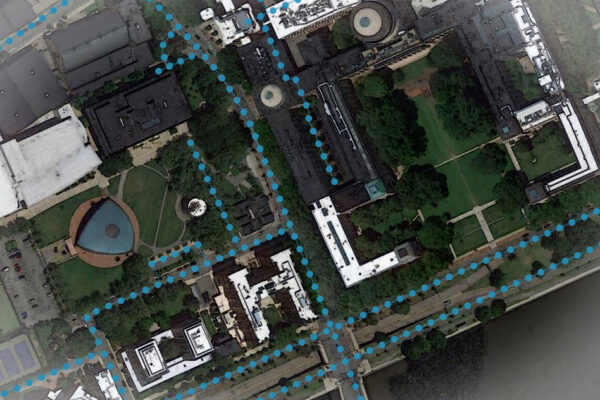
tag road features in digital maps. Image: Google Maps/MIT News
RoadTagger was first trained using a real-world map dataset, called OpenStreetMap, which lets users edit and curate digital maps around the globe. From that dataset, they collected confirmed road attributes from 688 square kilometers of maps of 20 U.S. cities — including Boston, Chicago, Washington, and Seattle. Then, they gathered the corresponding satellite images from a Google Maps dataset.
The researchers hope to use RoadTagger to help humans rapidly validate and approve continuous modifications to infrastructure in datasets such as OpenStreetMap, where many maps don’t contain lane counts or other details. A specific area of interest is Thailand, Bastani says, where roads are constantly changing, but there are few if any updates in the dataset.
“Roads that were once labelled as dirt roads have been paved over so are better to drive on, and some intersections have been completely built over. There are changes every year, but digital maps are out of date,” he says. “We want to constantly update such road attributes based on the most recent imagery.”
MIT – www.mit.edu
 If you enjoyed this article, you will like the following ones: don't miss them by subscribing to :