Big data sets drones to fly
His work combining the use of big data (historical data as well as various sources of satellite imaging) started during the in Iraq and Afghanistan wars when he would try to predict the risks of road-side improvised explosive devices (IEDs) and then send out surveillance drones to check the hot spots that his algorithms would yield.
"Very often, by flying a drone over the hot spots indicated by the predictive algorithm, we would be able to spot a person placing an IED some hours before a US military convoy would take a specific route, then even rewind the video to trace the person back to a bomb factory where the IED came from", Snitch told eeNews Europe.
This intelligence work was not too much publicized at the time, but being sensible to Africa’s elephants and rhinos anti-poaching causes, Snitch figured out that his probabilistic spatio-temporal models could certainly be tweaked to prevent poachers from reaching their targets.
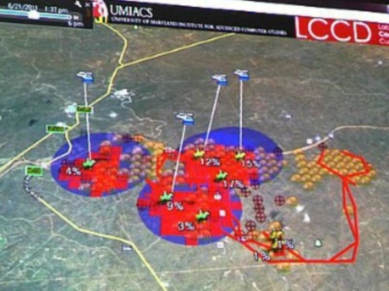
Last year, Snitch and his colleagues published a paper describing a data-driven, behavioural model based Anti-Poaching Engine, dubbed APE. The algorithm combines animal movement behaviours models and also models poachers’ behaviour based on historical data (from game park rangers’ observations) to churn out coordinated sets of flight paths for drones in the air and ranger patrols on the ground to best protect animals and intercept the poachers before they strike.

"We collected several years’ worth of data in South Africa and worked on it to identify mathematical patterns", explained Snitch. "Because some reserves are so wide, you could fly a drone for a month and not see a thing. The whole issue is to figure out how to reduce the space to be covered" he added.
So by crunching the data from safari sight-seeing, from past poaching incidents, snares or animal carcasses, by taking out from the map the areas where the animals are the least likely to be (for topographical reasons or because there are no water holes left during particular months), the researchers were able to design dynamic mathematical models that would hit it right.
"We have tested APE on private reserves in southern Africa for the last two years under Lindbergh Foundation’s Air Shepherd initiative, and whenever we operate our drones in a game park, poaching simply stops", said Snitch.

The drones are equipped with a GPS and two zooming camera systems (for visible and infrared light) mounted on gyro-stabilized gimbals. At night, the heat signatures of game or poachers is fairly easy to spot even from a long distance. During day time, the drones can be flown parallel to park fences to identify breaches (in a matter of minutes rather than several hours by car on difficult roads), drone operators will also collect geographical data as they spot animals.
In the future, Snitch would want to automate animal presence data collection using image processing. "The challenge is finding adequate computer power on a laptop in the bush", he noted.
Based on these results, SANParks (South African National Parks) announced that these UAV solutions will are now an integral part of their strategy to combat rhino poaching in the Kruger National Park.
The Lindbergh Foundation has also launched the Air Shepherd crowdsourcing campaign, aiming to raise USD500,000 to fully implement the program for one year at Kruger National Park with expansion planned over the next year to seven additional African countries (throughout Africa, an estimated 100,000 elephants were killed between 2010-2013 alone). The money collected will help buy drones and train more rangers.
For this good cause, Snitch plans to offer a free licence of APE to African universities willing to further develop this anti-poaching strategy, helping students collect appropriate data and tune the algorithm to the specifics of their countryside.
Snitch says his probabilistic spatio-temporal models could route drone flights for many other purposes, such as fighting illegal wood logging (one source of data could be freely accessible hyperspectral satellite imaging from the NASA), figuring out the spread of food crop diseases and their origins (based on foliage hyperspectral signatures, animal moves and wind patterns), or even to find lost peoples in national parks (apparently, dozens of trekkers get lost in American national parks every year, so there would be enough data to make sense of it).
Check out the Air Shepherd crowdsourcing campaign
Related articles:
Catcher drones to geo-fence industrial sites
Who owns the space above your garden?
Tracking offenders and consumers alike
Depth cameras interpret shoppers’ behaviour
 If you enjoyed this article, you will like the following ones: don't miss them by subscribing to :